


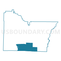
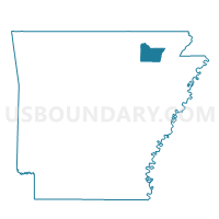
MARION Voting District, Lawrence County, Arkansas
About
Outline

Summary
| Unique Area Identifier | 527068 |
| Name | MARION Voting District |
| County | Lawrence County |
| State | Arkansas |
| Area (square miles) | 49.40 |
| Land Area (square miles) | 49.10 |
| Water Area (square miles) | 0.30 |
| % of Land Area | 99.40 |
| % of Water Area | 0.60 |
| Latitude of the Internal Point | 35.92219040 |
| Longtitude of the Internal Point | -91.10808770 |
Maps

Graphs
Select a template below for downloading or customizing gragh for MARION Voting District, Lawrence County, Arkansas


Neighbors
Neighoring Voting District (by Name) Neighboring Voting District on the Map
- ASHLAND Voting District, Lawrence County, AR
- Blackriver Marshall Voting District, Independence County, AR
- DOWELL Voting District, Lawrence County, AR
- LAWRENCE Voting District, Lawrence County, AR
- MORGAN Voting District, Lawrence County, AR
- Promised Land Voting District, Craighead County, AR
- Swifton Voting District, Jackson County, AR
Top 10 Neighboring County Subdivision (by Population) Neighboring County Subdivision on the Map
- Glass township, Jackson County, AR (1,088)
- Morgan township, Lawrence County, AR (562)
- Black River-Marshell township, Independence County, AR (341)
- Marion township, Lawrence County, AR (328)
- Dowell township, Lawrence County, AR (291)
- Lawrence township, Lawrence County, AR (260)
- Ashland township, Lawrence County, AR (240)
- Promised Land township, Craighead County, AR (190)
Top 10 Neighboring Place (by Population) Neighboring Place on the Map
Top 10 Neighboring Unified School District (by Population) Neighboring Unified School District on the Map
- Westside Consolidated School District, AR (9,112)
- Walnut Ridge School District, AR (6,135)
- Cedar Ridge School District, AR (5,465)
- Jackson County School District, AR (4,609)
- Hoxie School District, AR (3,914)
- Hillcrest School District, AR (3,680)
Top 10 Neighboring State Legislative District Lower Chamber (by Population) Neighboring State Legislative District Lower Chamber on the Map
- State House District 74, AR (30,962)
- State House District 58, AR (27,318)
- State House District 73, AR (26,277)
Top 10 Neighboring State Legislative District Upper Chamber (by Population) Neighboring State Legislative District Upper Chamber on the Map
- State Senate District 14, AR (91,166)
- State Senate District 12, AR (83,956)
- State Senate District 11, AR (80,865)
Top 10 Neighboring 111th Congressional District (by Population) Neighboring 111th Congressional District on the Map
Top 10 Neighboring Census Tract (by Population) Neighboring Census Tract on the Map
- Census Tract 12, Craighead County, AR (4,835)
- Census Tract 4904, Independence County, AR (4,283)
- Census Tract 4801, Jackson County, AR (3,490)
- Census Tract 4703, Lawrence County, AR (1,990)
- Census Tract 4704, Lawrence County, AR (1,690)
Top 10 Neighboring 5-Digit ZIP Code Tabulation Area (by Population) Neighboring 5-Digit ZIP Code Tabulation Area on the Map
- 72476, AR (7,155)
- 72433, AR (3,067)
- 72469, AR (1,124)
- 72471, AR (1,108)
- 72421, AR (554)
- 72410, AR (498)
- 72524, AR (376)
- 72427, AR (174)